Tuesday, 16 February 2010 Lake Hawea Station, Wanaka Airport
This was a big day for sightseeing. We signed up for a 4-hour air tour over the whole mountainous region of the central South Island. It was a great day for photography. Brief summary: we flew north an circled around Aoraki/Mt Cook, then southwest and landed at Milford Sound. After about 45 minutes on the ground we took off and flew around Mt Aspiring to the east, and then back to Wanaka.
All aboard!
Here is Mt Cook, also officially known by its Maori name Aoraki, the highest peak in NZ at 3784 m (just over 12,000 ft). It consists of 3 peaks, which you can see in this picture.
The third one, farthest in the distance, is the summit.
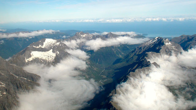
From there we flew over range after range of the Southern Alps, heading southwest. Each range was separated by a valley, most of which have an obvious stream draining them.
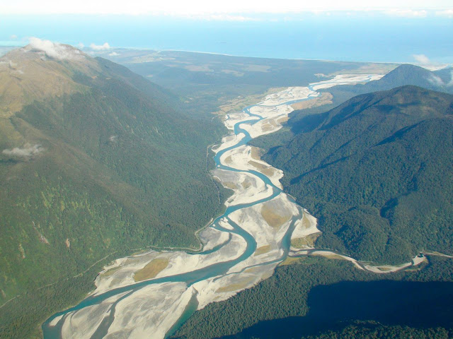
The major rivers are classic braided streams in a broad alluvial valley draining into the sea - in this case the Tasman Sea off the southwest coast of NZ.
Here is a high alpine lake. Its outlet is a cascading waterfall (which I didn't photograph because it wasn't visible from the angle of our route.)
The approach into the tiny aerodrome at the head of Milford Sound required precision landing by our experienced pilot. The final approach includes a sharp low-altitude turn to line up with the runway just seconds before touching down!
Here is the view seaward.
Milford sound is the only one of the many fiords in NZ that can be reached by paved road. Every day dozens of tour busses crowd the road through the mountains out to the visitor center at the head of the fiord. The harbor is very busy with tour boats coming and going all day. We had cruised into and out of the fiord aboard the MS Volendam on our Holland America cruise back in mid-December. It was very early in the morning, it was raining, and it was beautiful in its own way, with all of the waterfalls cascading down the sheer granite cliffs. But we didn't go in far enough even to glimpse the built-up tourist area, so this was a new experience for us. Once you are out on the ground, you realize what a beehive of activity it is. The helicopters and small planes alone keep the place humming, with one or the other taking off or landing virtually every five or ten minutes.
By the way, I think I have explained the difference between a sound and a fiord in an earlier posting, but here it is again. These so-called sounds on the southwest coast of New Zealand are misnamed. They are actually fiords. A sound is a drowned river valley - i.e., it was a river valley draining to the sea in an earlier time when the sea level was as much as 100 m lower than it is today. With today's higher sea levels, much of the river valley and all of its estuary are now under hundreds of feet of seawater. There are authentic sounds on the north coast of the south island, Queen Charlotte Sound prominent among them, part of the extensive system known as the Marlborough Sounds. Look at a map of New Zealand at the northeast top of the south island near the port of Picton to see what I mean.
In contrast, a fiord is a drowned glacial valley - the outlet where a glacier flowed into the ancient sea during the ice ages, carrying with it all of the detritus it had scoured from the mountains. The cross section or profile of the glacial valley is markedly different from that left by an ordinary river because of the enormous erosive efficiency of the glacier. All of these features in Fiordland National Park in New Zealand are fiords - duh, I wonder if that's why they named the National Park? They are the same sort of feature as the fiords of Norway, for exactly the same reasons.
Here we are approaching Mt Aspiring from the west. This mountain has the classic shape that geomorphologists call a "horn", the archetype of which is the famous Matterhorn in Switzerland. It is caused by three intersecting glacial cirques where three distinct arms of a high glacier each scours one face off the high terrain, leaving just the point in between.
We had the incredible good fortune to fly by just as two mountain climbers were trudging along the final ridge up to the summit. No joke - these pictures are undoctored and authentic. I asked the pilot how much he had to pay the climbers to time their final ascent to coincide with our flight!
Here is another one of those fantastic braided river valleys carrying the melt water from the remaining glaciers down to one of the many lakes in the area. New Zealand has done a great job of harnessing the energy potential of these lakes with hydroelectric power now providing 55% of net electricity generated. On the Waitaki river drainage alone there are at least 8 dams and hydroelectric power stations.
Lake Wanaka on approach to the Wanaka airport at the end of a fantastic flying adventure. WOW! I've got some great High Definition video, too, that I would love to share with you in person some day.


No comments:
Post a Comment